
The Roman Road
Rudgate and Newton Kyme
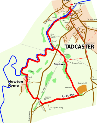
A slightly hilly walk to Smaws, Rudgate and Newton Kyme; returning along the banks of the River Wharfe to Tadcaster : almost 7 miles.
| Route Details | |
| Length | about 7 miles |
| Hills | A gentle hill |
| Underfoot | The route follows roads, tracks and footpaths, which can be muddy |
| Wheelchairs | Not suitable |
| Notes | There are no opportunities to buy refreshments on the route |
| Return to the Route List | |
DOWNLOAD a Print Version of the route
Google Maps - the route overlain on aerial photography.
OS Getamap - the route shown on OS maps can also be downloaded as GPS coordinates.
OS Explorer Map - "York, Selby & Tadcaster" EX290.

St Mary's Church, Tadcaster

The weir and viaduct, Tadcaster

The tunnel

The Hall, Newton Kyme

St Andrew's Church, Newton Kyme
The Route Described
The route starts at the Walking Roundel in Tadcaster Bus Station, cross the main road, turn left and cross the Tadcaster Bridge. A Tadcaster pastime is to lean over the parapet and spot the fish resting in the River Wharfe below. However, moving on ...
Once over the bridge, turn right along Wharfe Terrace and follow the public footpath past the church, the weir and on under the viaduct.
Tadcaster Viaduct is an interesting relic of Victorian railway history: a major railway bridge which never carried a main line railway. George Hudson had intended it carry a main line from York to Leeds. However, after construction of the line had commenced, including the building the viaduct, his railway empire collapsed in a famous financial scandal and the line was never completed. The viaduct remained unused until the late 19th century when it provided a siding to the extended Tadcaster mill on the other side of the river.
Keeping the river on the right, you will soon reach a flow measurement station on the banks of the river, and beyond this a tunnel. The flow station allows the Environment Agency to monitor the level of the river, a key resource in preventing flooding further downstream. The results appear here !..
Pass through the tunnel. This stone structure was once an abutment for a wooden bridge across the river. The bridge provided access to Healaugh Manor on the other side of the river, a building long since demolished.
The footpath follows close by the river at this point, and can be muddy and slippy. Keep going until you come to some steps up a stone wall. Go over the steps and carry straight on up to the road. (You will be returning to this stone wall later.)
Taking care to cross the main road and continue up the track to Smaws. This will take you over an old railway bridge which once spanned the Church Fenton to Harrogate line, opened in 1847 and closed by Dr Beeching in 1964.
Smaws House is the first building you will come to. Follow the track round to the right. Keep going, passing all the buildings and on past the wood on your right. On leaving the wood a splendid panorama opens out to the West and North.
Keep walking along the track past the old quarry site until you reach Rudgate, a small road. Rudgate follows the alignment of a roman road from Castleford towards Aldborough. Turn right at Rudgate and walk down the road until the cross-roads at Watson's Lane.
At the cross-roads, turn right and pass under the old railway line, coming to the main road. Cross over and head towards Newton Kyme village past the Tythe Barn (now a privtae house). From this point the route is signposted as the "Ebor Way".
Newton Kyme village has a long history going back to pre-historic times. In the fields to the left of the track leading in the village are the remains of a "henge", now only visible as crop marks. Beyond that, towards the river, is a large roman fort and an associated vicus. This was located to the east of the roman road, Rudgate, close to where the road crossed the River Wharfe at St Helen's Ford. (Daily Mail) In the village itself some minor remains of Kyme Castle, a fortified manor house, are visible in the grounds of Newton Hall. St Andrew's Church, which is next to the hall is well worth a visit, with memorials recording the association of the village with the Fairfax and Oglethorpe families.
Keep walking on the lane through the village until you come to a gate into the field in front of Newton Hall. Enter the field and pass in front of the Hall and the Church. Follow the wall on your left hand down to the river.
At the river, turn right and follow it downstream through several small gates to the stomne wall mentioned earlier. Return to Tadcaster along the riverbank and through the tunnel.
